Special Coverage Studies And Calculation
Special Coverage Studies And Calculation
AARMTech provides coverage studies for PAGA coverage study, Wifi coverage study, Radio Coverage Study, and CCTV Coverage Study. Let's dive in and look at all of the coverage studies we provide:
PAGA Coverage Study
AARMTech conducts all types of coverage studies, including PAGA coverage studies. The organisation has hired the best people to handle the PAGA sound coverage study, who will contribute to the construction of a master PAGA system to prevent any security escalation with their detailed expertise and extensive experience. Because the oil and gas business is especially susceptible to blasts and rapid firing, a PAGA coverage study is just as critical as any other security research. PAGA system coverage study is necessary to understand the threat and know when it is approaching, and it should be retracted by building the best PAGA system that will soundly alarm and allow the workplace to empty minutes before the tension explodes.
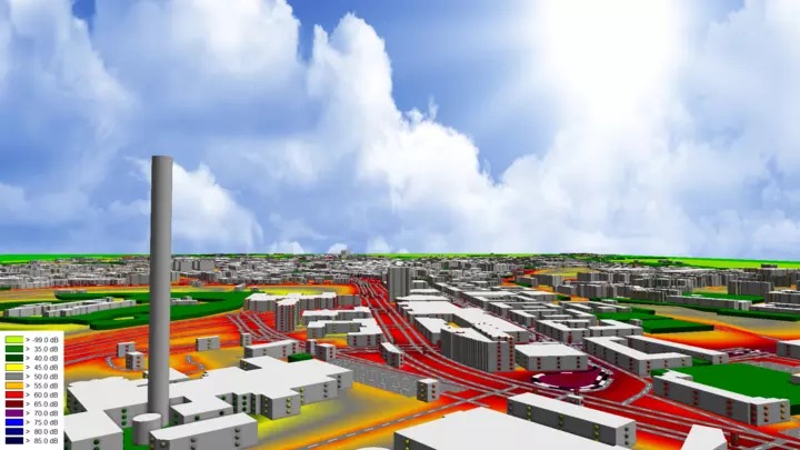
The software used for this type of coverage study is CadnaA and SoundPLAN.
CadnaA (Computer-Aided Noise Abatement) is the top programme for measuring, visualizing, evaluating, and forecasting ambient noise. CadnaA is made to manage all of these jobs, whether your goal is to investigate the noise emissions of an industrial facility, a retail establishment with a parking lot, a new road or rail layout, or even entire towns and urbanised regions. It is the ideal software to handle domestic and international noise calculation and noise mapping projects of any size thanks to its more than 30 implemented standards and guidelines, strong calculation algorithms, extensive object handling tools, outstanding 3D visualization, and extremely user-friendly interface. Aarmtech provides CadnaA coverage study services.
SoundPLAN is an acoustic ray tracing application developed by the German acoustical consulting business SoundPLAN GmbH for noise propagation prediction. The programme is a planning and modeling tool for acoustics with a variety of uses (urban planning, environmental assessment, noise analysis, noise control optimization, field noise mapping, OSHA/MSHA, etc.). The software SoundPLAN is focused on three-dimensional graphics. Several digital data interfaces and a digitizer are present. The programme creates colour noise contour plots and tabulations of the input and output information. Along with an industrial noise management module, SoundPLAN also has a tool for optimising wall and barrier designs. In terms of cost vs noise level reduction, graphic displays make the benefits of noise control techniques easier to understand.
Read more: PAGA Coverage Study
WiFi Coverage Study
Having a strong WiFi connection is great, but at the same time, a good WiFi coverage study is a cause for concern, especially in industries and businesses that have a high level of security system connected to WiFi. These security systems include video surveillance, drone systems, access control systems, integrated security systems, radio transmitters, satellites, time and attendance systems, and more. The WLAN must always be connected for everything to work smoothly. In addition, problems occur when the WiFi connection cannot reach these devices, is blank, and does not work at all.
All of the above tools and devices are data-oriented and these technologies require a powerful WiFi system that can work effectively by sending data to the owner. In this way, the owner is thoroughly informed of everything that is happening in and around the office space. All of this is done to promote a safer working environment. However, it requires a lot of WiFi coverage and the location can be well protected with higher performance.
The Acrylic software functions by specifying the physical places (buildings, floors, inner perimeter, and outside the perimeter) to which locations or a particular geographic region are connected. The system collects WiFi traffic through WiFi measurements and stores information about the devices, their signal strength, and other pertinent data to create maps with detailed coverage for each access point and to automatically generate editable reports with a diagnosis of the network situation and recommendations for improvement.
Read more: Wi-Fi Coverage Study
Radio Coverage Study
Radio Detection and Ranging System is what this term refers to. In essence, it is an electromagnetic system used to locate and measure the separation between an item and the site where the RADAR is installed. It operates by sending energy into space and observing the signal that is echoed or reflected from the objects. It uses the UHF and microwave frequencies to operate. Radar solutions are used for object detection which uses radio waves to determine the range and velocity of the object. AARMTech Radar solutions can capture images accurately by using geophysical equipment. We provide services in underground utilities and also our Radar solution is useful for scanning concrete, for verification purposes in the construction field, determining the concrete slab thickness, and for its utilities. AARMTech also provides Radar solutions in aerospace, ships, motor vehicles, and in weather formation.
Before a system (such as a trunked radio system) is put into use, thorough radio coverage research is carried out to show how well the site performs in terms of received signal coverage maps.
Last, but not least, the company also undertakes the services of security training and security consulting. In addition, the company has acquired the best security professionals who can in return help you to consult them with regard to any security issues or concerns arising at the doorstep of your firm. The company appoints these very professionals to meet with you and discuss the issues pertaining to the security of the firm. These very professionals then analyze your firm's security and bring about a great change to the company’s atmosphere that is blessed with robust security all over the firm. Hence, we promise to deliver the best Wifi coverage study, paga coverage along with security consultancy services excellently.
The Pathloss software is a thorough path design tool for radio networks that operate in the 30 MHz to 100 GHz frequency range. Path loss plays a significant role in the research and design of a communications system's link budget. Eight modules for path design, one for area signal coverage, and one for network integration of the radio pathways and area coverage analysis make up the program's structure.
Read more: Radio Coverage Study
CCTV coverage study
Closed-circuit television (CCTV) systems are something that is widely being used nowadays to keep an eye on traffic, deter crime, and guarantee public safety. However, rather than being assessed and visualized using a comprehensive technique, the success of CCTV coverage is frequently obtained by design experience and trial and error.
The JVSG System Design Tool creates an accurate representation of the intended video surveillance system using this data, for example, to assist in detecting any blind spots. System designers and system integrators just need to import 2D or 3D models of the end user's building or site, after which they may add project-specific data like the needed field of view and recommended installation height for each camera.
Read more: CCTV Coverage Study
DAS(Distribution Antenna System) Coverage Study
Distributed Antenna Systems (DAS) boost cellular coverage and data rates for commercial businesses and emergency public safety responses. Being able to receive appropriate DAS wireless and cellular coverage is crucial—it may even be the difference between life and death—whether you're in the middle of an emergency or merely a crucial call. A distributed antenna system (DAS) uses more than one antenna to cover the same area wirelessly while using less overall power and improving dependability. Hotels, subways, airports, enterprises, hospitals, and tunnels under roads may all have wireless service thanks to distributed antenna systems, which can be built for indoor or outdoor use. We take care of your network requirements so you may add a DAS solution to complement your network coverage and give clients a better network experience throughout your property.
LRDAS Coverage Study
Long Range Detection & Assessment System (LRDAS) is a category of radar sensors and long-range cameras that keep an eye on activities near or on important infrastructure regions including airports, seaports, military bases, international borders, oil & gas refineries, and other key industries, among others. Given that it has capacities ranging from a few hundred meters to more than 10 kilometers, the LRDAS is recommended in situations where long-range surveillance is necessary. The time available to respond to possible threats is increased since incursion is detected from a great distance, allowing employees to recognize the problem and make a security choice before it reaches the boundary. Using the most cutting-edge monitoring and sensor technologies available, we stop issues before they start, and we're always working to improve our security design procedure. Our objective is to offer an end-to-end solution that offers creative answers to emerging threats and technologies, regardless of the scope and complexity of the project.
RADAR
RADAR Radio Detection and Ranging System is what this term refers to. In essence, it is an electromagnetic system used to locate and measure the separation between an item and the site where the RADAR is installed. It operates by sending energy into space and observing the signal that is echoed or reflected from the objects. It uses the UHF and microwave frequencies to operate.
Radar solutions are used for object detection which uses radio waves to determine the range and velocity of the object. AARMTech Radar solutions can capture images accurately by using geophysical equipment. We provide services in underground utilities and also our Radar solution is useful for scanning concrete, for verification purposes in the construction field, determining the concrete slab thickness, and for its utilities. AARMTech also provides Radar solutions in aerospace, ships, motor vehicles, and in weather formation.
Steps including our services
- Feasibility Studies and reports
- Audit and Assessment of fecility
- Strategy preparation
- Basic Design & Detailed Engineering
- ‘For Tender‘ or ‘For Construction‘ Design Packages
- Procurement Management Support
- Project Management during construction and implementation phases - PMP methodologies
- Installation assessment, Monitoring, Testing witness and Handover engineer service"